
This article explores the significance of 3D rendering for master planning, focusing on aerial views and site context to enhance the decision-making process.
Evolution of 3D Rendering for Master Planning
Traditionally, master planning heavily relied on two-dimensional representations such as maps, blueprints, and sketches. While these methods conveyed basic information, they often fell short of capturing the complexity and dynamism of real-world environments. The advent of 3D rendering technology has transformed this landscape, allowing for more accurate, realistic, and intuitive depictions of spatial relationships and design elements.Aerial Views as a Key Component
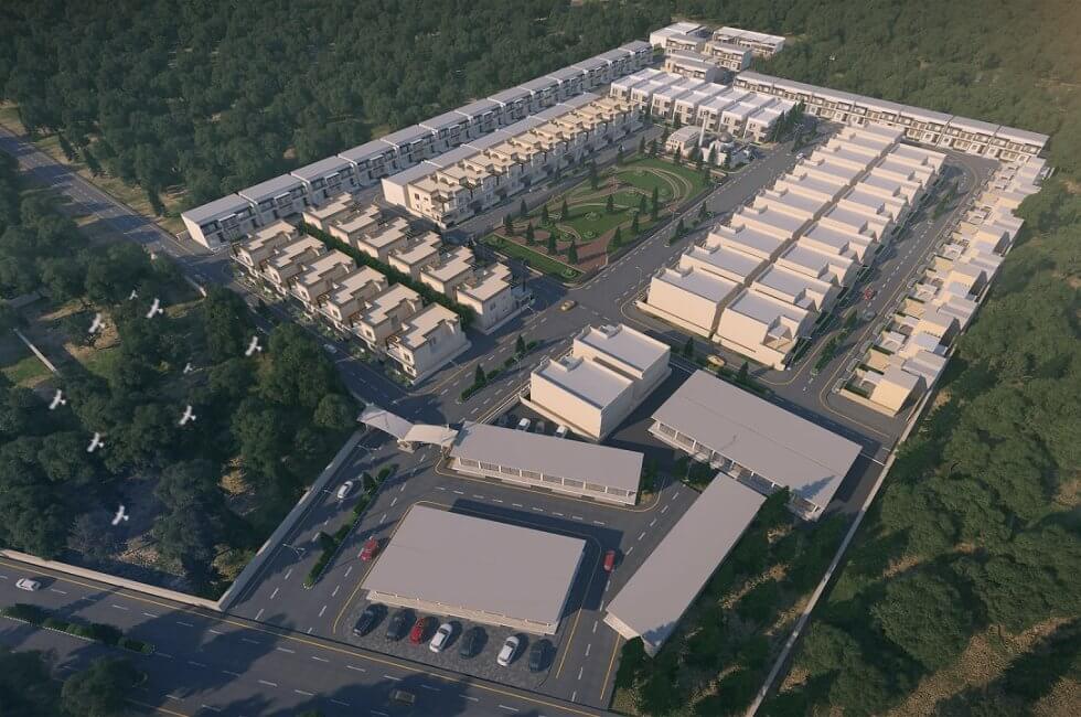
Aerial views offer a unique perspective, providing a comprehensive overview of the entire site and its surroundings. In fact, 3D rendering allows for the creation of highly detailed and accurate aerial visualizations, enabling stakeholders to grasp the spatial context and topography of the area. This perspective aids in identifying potential challenges, opportunities, and optimal design solutions. Precisely, aerial views encompass,- Comprehensive Overview: Aerial views provide a holistic understanding of the site, encompassing its entirety and the surrounding environment.
- Spatial Context: 3D rendering enhances spatial awareness, allowing stakeholders to grasp the interplay between various elements within the site.
- Topographical Insight: Detailed and accurate topographical representation aids in understanding the terrain, elevations, and natural features.
- Challenges Identification: Aerial perspectives help identify potential challenges, such as land constraints or environmental factors, influencing the planning process.
- Opportunity Recognition: Visualization from above aids in spotting opportunities for optimization, maximizing land use efficiency and design innovation.
- Stakeholder Engagement: Aerial views serve as powerful tools during stakeholder engagements, facilitating clearer communication of design intent.
- Strategic Decision-Making: The comprehensive aerial view assists planners in making strategic decisions aligned with the larger context of the site.
- Optimal Design Solutions: By providing a bird's-eye view, 3D rendering enables the exploration of optimal design solutions that harmonize with the site's characteristics.
- Integration with GIS Data: Aerial views seamlessly integrate with Geographic Information System (GIS) data, enriching the planning process with geospatial information.
- Dynamic Visualization: Realistic 3D rendering for master planning allows for dynamic visualization, helping stakeholders foresee the evolution of the site over time.
- Holistic Planning: Aerial perspectives encourage a holistic approach to master planning, considering the site as part of a larger urban or natural context.
Improved Decision-Making through Site Context
Understanding the site context is paramount in master planning, as it involves analyzing the surrounding environment, infrastructure, and potential impacts on the proposed project. 3D rendering facilitates the incorporation of these contextual elements into the planning process. Accurate depictions of neighboring structures, natural features, and transportation networks empower planners to make informed decisions that align with the existing fabric of the community.Enhanced Stakeholder Communication
Effective communication is fundamental in the success of any master planning project. 3D rendering for master planning not only aids in internal decision-making but also serves as a powerful tool for conveying the vision to stakeholders, investors, and the community at large. Aerial views and site context visualizations provide a common ground for discussion, ensuring that all parties involved share a cohesive understanding of the project's scope and impact.Here’s how architectural walkthroughs enhance client communication.
Simulation of Design Scenarios
One of the most significant advantages of 3D rendering is its ability to simulate various design scenarios. Planners can explore different layouts, building placements, and landscape designs in a virtual environment. This flexibility allows for iterative refinement of the master plan, ensuring that the final proposal aligns with both the project goals and the contextual nuances of the site.Also check why is landscape architecture important.
Data-Driven Decision Support
Integrating data into the master planning process is essential for making informed decisions. 3D rendering can be coupled with GIS (Geographic Information System) data, environmental data, and demographic data to create a holistic model. This data-driven approach provides planners with valuable insights into factors such as sunlight exposure, wind patterns, and population density, enabling more sustainable and resilient design solutions.Addressing Environmental Concerns
Master planning in the 21st century requires a strong emphasis on sustainability and environmental considerations. 3D rendering allows for the visualization of environmental impacts, such as shading analysis, green space distribution, and water flow simulations. This aids planners in creating environmentally conscious designs that mitigate negative effects on the ecosystem.Challenges in Rendering Aerial Views and Site Context
Computational Complexity
Rendering detailed and expansive aerial views with intricate site context demands substantial computational power. High-resolution models, especially in large-scale urban planning, can strain computing resources. As projects grow in complexity, ensuring real-time responsiveness during design exploration becomes a computational challenge. This challenge is particularly pronounced when attempting to render vast geographical areas with numerous buildings and environmental features.Data Integration
The effectiveness of 3D rendering for master planning heavily relies on the integration of diverse datasets. Combining topographic information, land use data, and infrastructure details with 3D models can be a complex task. Ensuring the accuracy, consistency, and real-time synchronization of these datasets poses challenges. The integration of real-time data, such as traffic patterns or environmental conditions, into the rendering process, is crucial for creating a dynamic and responsive planning environment.Accessibility
While 3D rendering has become more prevalent, accessibility remains a challenge, particularly for smaller municipalities or organizations with limited resources. Specialized software, hardware requirements, and the expertise needed to navigate these tools can create barriers. Addressing these challenges is essential to democratize the benefits of 3D rendering for master planning, ensuring that it becomes a widely accessible tool for planners, architects, and community stakeholders.Future Developments in Aerial Views and Site Context Rendering
Artificial Intelligence (AI) Integration
The integration of artificial intelligence into 3D rendering processes holds significant promise. AI algorithms can streamline the rendering pipeline, optimizing computational efficiency. Machine learning algorithms can also enhance the accuracy of contextual data integration, automating the extraction and interpretation of information from various sources. This advancement can alleviate the burden on planners, allowing them to focus on design decisions rather than technical intricacies.Real-Time Rendering
The future of 3D rendering for master planning lies in real-time rendering capabilities. Advancements in graphics processing units (GPUs) and rendering algorithms enable the generation of high-quality visualizations in real-time. This not only enhances the design exploration process but also facilitates dynamic, interactive presentations during stakeholder engagements. Real-time rendering provides an immersive experience, allowing planners to make on-the-fly adjustments and observe the immediate consequences.Augmented Reality (AR)
Augmented reality is poised to revolutionize how planners interact with 3D renderings. By overlaying virtual elements onto the real-world environment, AR technologies enable planners to visualize proposed changes on-site. This fosters a deeper understanding of the spatial relationships between the proposed project and its surroundings. Stakeholders can walk through virtual models, experiencing the proposed changes firsthand, which enhances communication and decision-making.Environmental Simulation and Analysis
Future developments will likely see a more integrated approach to environmental simulation within 3D renderings. Advanced algorithms can simulate sunlight and shadow patterns, wind flow, and other environmental factors. This not only aids in designing environmentally sustainable spaces but also allows planners to assess the impact of a project on its surroundings more comprehensively.Collaborative Cloud-Based Platforms
To address accessibility challenges, the development of collaborative, cloud-based platforms for 3D rendering is essential. These platforms would enable planners and stakeholders to access and contribute to the master planning process from various locations. Real-time collaboration in a cloud-based environment ensures that all stakeholders are working with the most up-to-date information, fostering a more inclusive and collaborative planning approach.Conclusion
In conclusion, the incorporation of 3D rendering, particularly through aerial views and site context visualizations, has revolutionized the field of master planning. The ability to create immersive and realistic representations of proposed projects facilitates better decision-making, improves communication with stakeholders, and allows for a more nuanced understanding of the site and its surroundings. As technology continues to advance, the future of master planning holds exciting possibilities, where virtual simulations and data-driven insights will play an increasingly integral role in shaping sustainable and resilient urban environments.Archxstudio takes pride in leveraging 3D rendering technology to provide clients with immersive aerial views and site context visualizations, enhancing master planning. Our solutions empower informed decision-making and stakeholder engagement.
Author | Mubashrah Rahim